Home → Hunting & Trapping → Hunting → Game Species → Deer → Expanded Archery Season on Deer → South Coastal Maine Area
Boundary Description for the Expanded Archery Season on Deer - South Coastal Maine Area
To view PDF documents, you will need the free Adobe Reader. If you need assistance, view our PDF Help page, or email us.
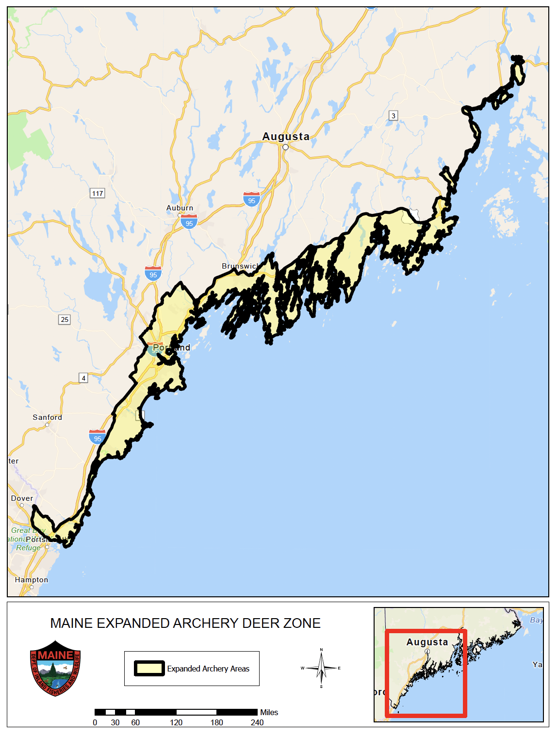
Parts of Bucksport, Elliot, Kittery, South Berwick, Cumberland, Falmouth, North Yarmouth, Portland, Scarborough, South Portland, Westbrook, Windham, Yarmouth, Camden, Owl's Head, Rockland, Rockport, and Thomaston—as well as areas of WMD 24:
Beginning where the Interstate Highway #95 bridge crosses the Piscataqua River in Kittery; then following the coast of Maine northwesterly and northerly to the State Route #101 (Dover-Eliot Road) bridge in Eliot; then following State Route #101 southeasterly to the junction of Interstate Highway #95; then following the southern edge of the northbound lane of Interstate Highway #95 northeasterly to State Route #91 (Cider Hill Road) in York; then following State Route #91 southeasterly to U.S. Route #1; then following U.S. Route #1 northerly to the railroad tracks in Arundel; then following the railroad tracks northerly to the Biddeford Turnpike Access Road (Precourt Street); then following the access road northwesterly to State Route #111; then following State Route #111 westerly to Interstate Highway #95; then following the southern edge of the northbound lane of Interstate Highway #95 northeasterly to the junction of Interstate Highway #95 and Broadturn Road in Scarborough; then following Broadturn Road northwesterly to Holmes Road; then following Holmes Road northeasterly to Beech Ridge Road; then following Beech Ridge Road northerly to where it becomes Saco Street; then following Saco Street northerly to Main Street in Westbrook; then following Main Street easterly to Bridge Street; then following Bridge Street northerly to Cumberland Street; then following Cumberland Street northwesterly to where it becomes River Road; then following River Road northwesterly to Anderson Road; then following Anderson Road northeasterly to where it becomes Hardy Road in Falmouth; then following Hardy Road northeasterly to where it becomes Duck Pond Road; then following Duck Pond Road easterly to Mast Road; then following Mast Road northerly to Blackstrap Road; then following Blackstrap Road northerly to where it becomes Skillin Road in Cumberland; then following Skillin Road northeasterly to Blanchard Road; then following Blanchard Road northwesterly to Orchard Road; then following Orchard Road northeasterly to where it becomes Haskell Road; then following Haskell Road northeasterly to State Route #115 (Gray Road) in North Yarmouth; then following State Route #115 southeasterly to the power line corridor; then following the southern edge of the power line corridor northeasterly to the intersection with North Road; then following North Road easterly to Milliken Road; then following Milliken Road northeasterly to West Pownal Road; then following West Pownal Road southerly to Hallowell Road (State Route #9); then following Hallowell Road northeasterly to Royal Road; then following Royal Road southeasterly to Hodsdon Road; then following Hodsdon Road southeasterly to where it becomes Granite Street; then following Granite Street southeasterly to the railroad tracks in Yarmouth; then following the railroad tracks northeasterly to Interstate Highway #295 in Freeport; then following the southern edge of the northbound lane of Interstate Highway #295 northeasterly to the Androscoggin River bridge in Brunswick; then following the western shore of the Androscoggin River easterly to the western shore of the Kennebec River in Bath and the U.S. Route #1 bridge over the Kennebec River; then following U.S. Route #1 easterly to the junction of U.S. Route #1 and Dexter Street in Thomaston; then following Dexter Street northerly to Old County Road; then following Old County Road northeasterly to Thompson Meadow Road in Rockland; then following Thompson Meadow Road northwesterly to West Meadow Road; then following West Meadow Road northerly to Mountain Road; then following Mountain Road northerly to Bog Road; then following Bog Road northerly to Gurney Street; then following Gurney Street easterly to Old Rockland Road in Rockport; then following Old Rockland Road northerly to Rockville Street; then following Rockville Street easterly to Rockland Street; then following Rockland Street southerly to Porter Street; then following Porter Street easterly to South Street; then following South Street southeasterly to the junction of South Street and U.S. Route #1 (Commercial Street); then following U.S. Route #1 northerly to the junction of U.S. Route #1 and John Street in Camden; then following John Street northwesterly to Mechanic Street; then following Mechanic Street westerly to Melvin Heights Road; then following Melvin Heights Road northwesterly to Molyneaux Road; then following Molyneaux Road northeasterly to Beaucaire Avenue; then following Beaucaire Avenue northerly to Canaan Lane; then following Canaan Lane northeasterly to Woodland Road; then following Woodland Road southeasterly to Beaucaire Avenue; then following Beaucaire Avenue easterly to the junction of Beaucaire Avenue and State Route #52 (Turnpike Drive, which turns into Mountain Street); then following State Route #52 southerly to the junction of State Route #52 and U.S. Route #1; then following U.S. Route #1 northerly to where the U.S. Route #1 bridge crosses the western shore of Verona Island; then following the northwestern shore of Verona Island to the U.S. Route #1 bridge into Bucksport; then following U.S. Route #1 to Hinks Street in Bucksport; then following Hincks Street northerly to Pond Street; then following Pond Street easterly to Wenbelle Drive; then following Wenbelle Drive northerly to Broadway; then following Broadway easterly to a point where the southeastern corner of property owned by the town and referred to as the Miles Lane Property intersects Broadway; then following the eastern line of the Miles Lane Property northerly to the CMP right of way; then following the CMP right of way easterly to a point where the southeastern corner of land owned by the town and referred to as the New Middle School Property intersects the CMP right of way; then following the eastern line of the New Middle School property northerly to the northeastern corner of the New Middle School Property; then following the northern line of the New Middle School Property westerly to the northwestern corner of the New Middle School Property; then following the western line of the New Middle School Property southerly to the CMP right of way; then following the CMP right of way westerly to a point where Forest Hill Street intersects the CMP right of way; then following Forest Hill Street southerly to Broadway; then following Broadway westerly to Central Street; then following Central Street southerly to School Street; then following School Street northwesterly to MacDonald Street; then following MacDonald Street southerly to Scott's Lane; then following Scott's Lane westerly to a point where Scott's Lane intersects the eastern line of the property owned by Webber Tanks; then following the eastern line of the property owned by Webber Tanks southerly to the southeastern corner of the land owned by Webber Tanks; then following the southern line of the property owned by Webber Tanks westerly to State Route #15/River Road; then following State Route #15 northwesterly to the point of origin at a point on the eastern side of State Route #15/River Road where the Central Maine Power line right of way intersects State Route #15; then following the right of way northeasterly to a point where it intersects a second CMP right of way extending generally in an east to west direction; then following the second CMP right of way easterly until it intersects Silver Lake Road; then following Silver Lake Road northerly to a point where the road right of way intersects the southern shore of Silver Lake; then following the southern shore of Silver Lake northeasterly and then southeasterly to a point where the shore intersects the access road leading from Central Street to the Silver Lake dam; then following the access road easterly to Central Street; then following Central Street northeasterly to Race Course Road; then following Race Course Road easterly to where it becomes Donovan Road and then easterly beyond its eastern terminus to the northeastern corner of the land of the Penobscot Nursing Home; then following the eastern line of the property of the Penobscot Nursing Home southerly to the CMP right of way; then following the right of way easterly to State Route #46; then following State Route #46 southwesterly to U.S. Route #1; then following U.S. Route #1 approximately 250 meters westerly to the Bucksport/Orland town line; then following the Bucksport/Orland town line southwesterly to the northern shore of the Penobscot River; then following the northern shore of the Penobscot River westerly to a point where the eastern line of the property owned by Hannaford Brothers intersects the northern shore of the Penobscot River; then following the eastern line of the property owned by Hannaford Brothers northerly to U.S. Route #1; then following U.S. Route #1 westerly to where the U.S. Route #1 bridge crosses the northern shore of Verona Island; then following the shore of Verona Island starting easterly around the perimeter of the island to where the U.S. Route #1 bridge crosses the western shore of Verona Island; then following U.S. Route #1 westerly to where it crosses the eastern shore of Prospect; then following the shoreline and remaining southerly of U.S. Route #1 along the coast of Maine to where the U.S. Route #1 bridge crosses the Piscataqua River in Kittery; then following the coast of Maine to the point of origin where the Interstate Highway #95 bridge crosses the Piscataqua River in Kittery, except that where U.S. Route #1 crosses the Maine coast, then U.S. Route #1 serves as the southerly boundary.
Note: Islands that are part of WMDs 24, 25, and WMD 26 west of the Orland River and connected to the mainland part of the South Coastal Maine Expanded Archery Area at low tide or by man-made structures are considered part of the South Coastal Maine Expanded Archery Area. The Portsmouth Navy Shipyard at Seavey Island is not included in this expanded archery area. The discharge of firearms and archery hunting equipment is prohibited by ordinance in the entire City of Portland. This eliminates the possibility of hunting deer in Portland.